在线发表数据采集 (online dataset)
Article: Synthesizing Disparate LiDAR and Satellite Datasets through Deep Learning to Generate Wall-to-Wall Regional Inventories for the Complex, Mixed-Species Forests of the Eastern United States (data) (doi)
Data: Ayrey, E., D.J. Hayes, and J.B. Kilbride. 2021. New England Enhanced Forest Inventory ver 1. Environmental Data Initiative. https://doi.org/10.6073/pasta/e0dfb8220980bad60d1edb24ebd9d055 (Accessed 2022-01-04). (Download Zip Archive)
Article: Tao, S., Labrière, N., Calders, K. et al. Mapping tropical forest trees across large areas with lightweight cost-effective terrestrial laser scanning. Annals of Forest Science 78, 103 (2021). (doi)
Data: BLK360_PetitPlateau (link) TLS
全球和中国机场地理数据集 (OurAirports) (w-link)
生态地理区域划分 (w-link)
2021版全国1:100万公众版基础地理信息数据 (全国地理信息资源目录服务系统)
常用的行政区划数据介绍与下载教程 (锐多宝) (download) (BaiduNetDisk: 4444)
67.4万张RADARSAT-1雷达影像公开免费下载 (GIScience) (EODMS download)
全球地名数据资源下载(1100万个地名) (GISer last)
HYDE:全球环境历史数据库 (GISer last)
Tree LiDAR Data (open or published)
Terrestrial LiDAR of tropical forests (page) (LUCID project)
TLS- Quantitative Structure Models (download)
- TLS tree point cloud data (download)
3D Forest Tools (homepage)
- Automated method for basic tree parameters can be fast and precise.
- Investing in the Forest Service with Lidar Data (US Forest Service)
A remote sensing derived data set of 100 million individual tree crowns for the National Ecological Observatory Network (article)
- The dataset is available at https://zenodo.org/record/3765872#.X2J1zZNKjOQ.
- NEON Tree Crowns Dataset
- Terrestrial lidar data collected from four large tropical rainforest trees in Floresta Nacional de Caxiuanã (zenodo)
TLS - Supplementary Material: "A Density-Based Algorithm for the Detection of Individual Trees from LiDAR Data" (zenodo)
- NEON Tree Crowns Dataset (zenodo)
- Data for the NeonTreeEvaluation Benchmark (zenodo)
- LiDAR dataset of Forest Park (Maohua Liu) (figshare) (https://doi.org/10.6084/m9.figshare.12832115.v1) This is an airborne LiDAR data, which is part of Saihanba National Forest Park, including white birch and larch.
ALS - EDI Data Portal edirepository (page)
- Terrestrial LiDAR Scans in the CTFS-ForestGEO Plot at Harvard Forest 2021 (edi)
TLS - Point cloud data from terrestrial laser scanning for stem volume modelling of Scots pine trees (zenodo) (230 Scots pine trees (Pinus sylvestris L.)) (includes 230 laz-files)
TLS - New insights into tree architecture from mobile laser scanning and geometry analysis (zenodo) (https://doi.org/10.5061/dryad.2fqz612n6) (dryad)
MLS - Results Available for International Benchmarking of Terrestrial Laser Scanning Methods
The single- and multi-TLS data, as well as the reference data, of six sample plots of this benchmarking project can be downloaded from here.TLS
数据存储/检索平台
https://zenodo.org/
https://datasetsearch.research.google.com/
https://portal.edirepository.org/nis/advancedSearch.jsp
https://datadryad.org/
title: Research Data Collection - SciDataLib
app: markdown
date: 2019-12-05 10:25
Home page
Remote sensing data
- Atmospheric Composition Analysis Group
link (target=_blank) | 加拿大Dalhou-sie University大气成分分析研究组--全球全覆盖的PM2.5浓度数据 - 免费DEM中分辨率最高的ALOS 12.5米 DEM下载方法 | link (target=_blank)
- !(Image)(https://twitter.com/i/status/1204322375694798851)
- The CEDA Archive - Centre for Environmental Data Analysis (自然环境研究委员会大气科学和地球观测数据库) | LINK (target=_blank)
ESA climate change initiative | link
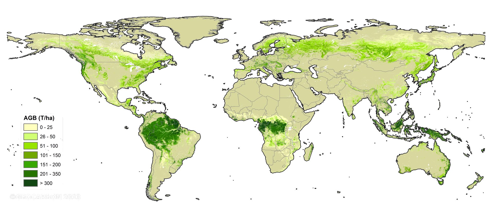
- New biomass map taking stock of the world's carbon

- 随着植物的生长,它们从大气中清除二氧化碳并将其作为生物质存储。然后通过森林砍伐,干扰或野火等过程将其释放回大气中。评估这些动态变化是了解碳循环的关键,也是了解有助于预测未来变化的全球气候模型的关键。
- 新地图使用了2017年和2018年从多颗地球观测卫星获得的光学,激光雷达和雷达数据,并且是第一个结合了哥白尼前哨1号任务和日本ALOS任务的多次数据采集的地图。
- 研究团队的下一步是绘制涵盖2018-19期间的地图,并量化各年之间的变化。
- Reflecting on the importance in understanding the dynamics of the world’s forest carbon tore, ESA plans to launch a new Earth Explorer Biomass mission in 2022. The mission will carry the first P-band synthetic aperture radar, whose data will enable even more accurate maps of tropical, temperate and boreal forest biomass and will witness at least eight growth cycles in the world’s forests during its operational lifetime.
- New biomass map taking stock of the world's carbon
ESA DUE Globbiomass project (target=_blank)

ALOS Global Digital Surface Model "ALOS World 3D - 30m (AW3D30)" | link
- [] Version 2.2 released in April 2019
- [] Version 2.1 released in April 2018
- [] Version 1.1 released in March 2017
NASA发布的更新的全球高程数据 2020年2月13日
Release of NASADEM Data Products
- 改进是通过用更新的算法和辅助数据重新处理原始SRTM雷达信号数据和遥测数据实现的,这些数据在原始SRTM处理时是不可用的。
- 新的全球数字高程模型(DEM)已发布。 NASADEM是对航天飞机雷达地形任务(SRTM)数据的重新处理,以提高高度精度并填充缺失的高程数据。 通过使用原始SRTM数据发布时还没有的算法和数据,数据得到了改善。 使用ASTER GDEM高程对SRTM中的丢失数据进行了优化。
- The newly available NASADEM data products are available with a 1 arc second resolution. Other radar products were released with the updated DEM. All NASADEM products are available for land between 60° N and 56° S latitude, representing 80% of all the Earth’s landmasses. All datasets can be downloaded from NASA’s Land Processes DAAC (LP DAAC) https://lpdaac.usgs.gov/news/release-nasadem-data-products/
- NASADEM Merged DEM Global 1 arc second - NASADEM_HGT
- VIEW RELATED INFORMATION - USER'S GUIDE https://lpdaac.usgs.gov/documents/592/NASADEM_User_Guide_V1.pdf?_ga=2.128905868.1856898291.1584409135-959088435.1584409135
- NASA JPL (2020). NASADEM Merged DEM Global 1 arc second V001 [Data set]. NASA EOSDIS Land Processes DAAC. Accessed YYYY-MM-DD from https://doi.org/10.5067/MEaSUREs/NASADEM/NASADEM_HGT.001
- NASA发布全新全球30米分辨率DEM—NASADEM | w-link
清华大学何杰博士和阳坤教授在《Scientific Data》发布中国区域高分辨率气象驱动数据集(1979-2018) Weixin_link (target=_blank) | data_link (target=_blank) | article_link (target=_blank)
- 1️⃣ 一套服务于陆面、水文、生态等地表过程模型的中国高时空分辨率气象数据集。
- 2️⃣ 该数据集覆盖了中国陆地区域,时间跨度为 40 年(1979-2018),空间分辨率 0.1 度,时间分辨率 3 小时,包括了近地面气温、气压、比湿、全风速、向下短波辐射通量、向下长波辐射通量、降水率等 7 个变量。
- 西北农林科技大学彭守璋在《Earth System Science Data》发布了我国目前时间序列最长、空间分辨率最高、覆盖面积最广的月气候数据集。1901-2017年中国1km分辨率月气候数据集(包括月最低温、最高温、均温及降水量)。 | weixin_link | article_link | DOI: 10.5194/essd-11-1931-2019 | data_link
- 中国通量观测研究联盟:http://www.chinaflux.org/general/index.aspx?nodeid=25
- 2019年全球森林冠层高度数据集 w-link | https://glad.umd.edu/dataset/gedi/
Landsat分析就绪数据 (Analysis Ready Data, ARD) (http://ceos.org/ard/) | w-link
- 美国马里兰大学地理科学系全球土地分析和发现研究团队 (Global Land Analysis and Discovery, GLAD) 的Peter Potapov博士在Remote Sensing期刊上发表了一篇利用Landsat 分析就绪数据探讨土地覆盖利用的研究论文,其制作的Landsat分析就绪数据 (GLAD ARD),适用于国家乃至全球的经验性土地覆盖和变化检测。
- GLAD ARD表征了从1997至今的Landsat归一化地表反射率时间序列,重访周期16天,每年更新一次。
- GLAD ARD提供了一系列基于深度学习进行多时段遥测数据处理和表征的工具,可作为基于Landsat的自然资源评估和监测的解决方案。用于水、森林和农作物制图的GLAD ARD数据和工具已在全球范围内实施。
- GLAD网站上提供了能够免费访问的GLAD ARD数据和工具 (https://glad.umd.edu/ard/home) 。
- 除了ARD数据集外,GLAD团队还开发并向用户提供了一系列用于时间序列数据处理,分析和深度学习特征描述的工具。
- 全球GLAD ARD数据集、ARD分析和表征工具均向用户提供了基于Landsat的免费自然资源评估和监测的端到端解决方案。
Basic geographic information data
- 全国路网水系、精确到乡镇的行政区划等矢量shp免费下载 | article link |
链接:https://pan.baidu.com/s/1BbH4gKKk0swv34EP6ApNaA 提取码:as3a - 全球人口数据集LandScan(2000-2018)--美国能源部橡树岭国家实验室 | LandScan link (target=_blank) | Download (target=_blank)
- GADM全球(国家、省、市、县)矢量边界 | GADM
v.36 - A homogenized daily in situ PM2.5 concentration dataset in China during 2015-2019. PANGAEA, https://doi.org/10.1594/PANGAEA.917557 | A homogenized daily in situ PM2.5 concentration dataset from national air quality monitoring network in China, Earth System Science Data. DOI: 10.5194/essd-2020-121
- 全球1:100万行政区划、全球1:100万冰川数据集 | w-link
Technique article
- R-如何在NC时间堆叠数据集中根据坐标提取数据并展示其趋势 | link (target=_blank)
GIS data
- 如何获取生物多样性观测数据? | w-link
GBIF(全球生物多样性信息网络)网址:https://www.gbif.org/ - 气象数据-全国温室数据系统 | 农业部规划设计研究院设施农业研究所
- 中国区域地面气象要素驱动数据集(1979-2018)| 国家青藏高原数据中心
LiDAR data
- Brazil: Lidar (and forest inventory) datasets can be downloaded from the Sustainable Landscapes Brazil Project (https://www.paisagenslidar.cnptia.embrapa.br/webgis/) across several locations in Brazil. An example application for this dataset can be found in our paper at DOI: 10.1117/1.JRS.14.034518.
Update: 2020-10-14 20:44:02
本作品采用 知识共享署名-相同方式共享 4.0 国际许可协议 进行许可。
评论已关闭